Bridleways & Tracks In The Chess Valley
Chess Valley Bridleways Association members enjoy very good off-road riding, more often than not on permissive or licensed tracks or byways, rather than on official bridleways. Many of our local roads, because they are relatively quiet, also offer safer riding opportunities. See below for a sketch map and some suggested routes that you could try.
The best source of local maps for Bridleways is the Chiltern Society, with map numbers 5 & 17 being particularly useful. On the outer edges of our area Maps 6 and 28 are also helpful. If you are interested in the types of Horse Tracks available this blog post might help.
Riding locally you can anticipate encountering the following challenges, amongst others:
- tractors and lorries (including horse boxes)
- cyclists and bikers
- walkers and dogs
- bird scarers and shoots
- occasionally – the Kimblewick Hunt
Please wear high visibility clothing, acknowledge and thank all other road users, and be pro-active in providing helpful hand signals.
Horse friendly pubs – two local pubs, in particular, welcome horses. Riders can phone the Plough at Belsize, between Sarratt and Chipperfield, to arrange the parking for horse boxes or trailers, provided you call in for a snack/drink as well. The Green Dragon at Flaunden are happy for horses to be held in the car park, so long as you call in for a drink!
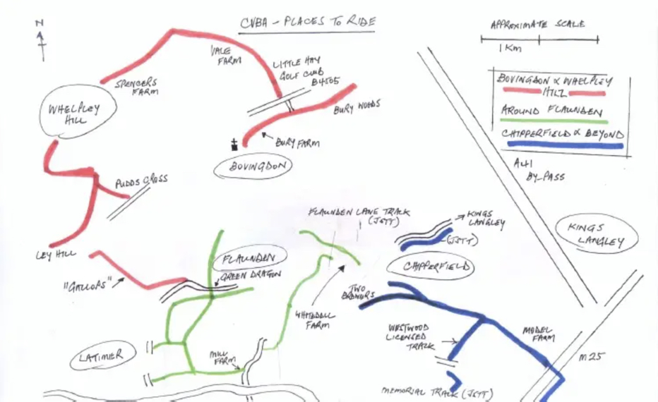
The image below indicates in red, green and blue local places to ride, around Bovingdon, Flaunden and Chipperfield. It is only intended to show in broad terms three areas of good, off-road riding. It is not adequate for ‘on horse’ use!
We do examine each area in detail and offer four basic routes, one in each area. It is, of course, quite feasible to link together either two areas, or even all three!
That would demand quite a bit of stamina from both horse and rider though!
Routes In More Detail
If you’d like more information and detail on the routes, please click one of the boxes below to download a PDF route guide for each one.
If you are a CVBA member, log into the site where you can get full access to our Google Map, showing all bridleways, permissive tracks, licensed tracks and by-ways that are available to ride in the area.

